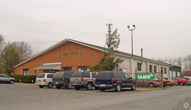
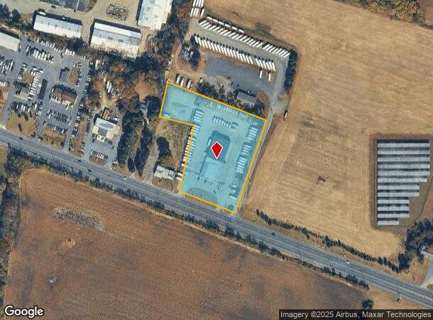
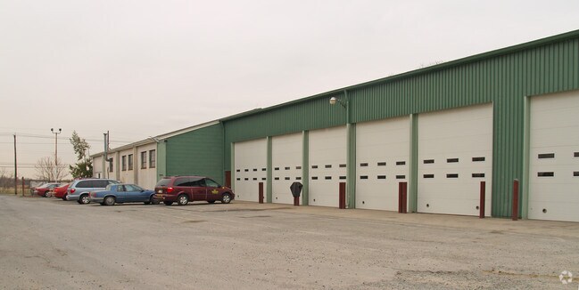
Property Record
1897 Route 38, Southampton, NJ 08088

NEARBY LISTINGS FOR SALE OR LEASE
Property Detail
1897 Route 38
33-00403-0000-00012-02
Burlington
Vacantlandnec
New Jersey
X
12.2
34005C0276F
3.50 AC
2024
South Burlington County
2025
Philadelphia
703202
Philadelphia-Camden-Wilmington, PA-NJ-DE-MD
12,231 SF
DEMOGRAPHICS near 1897 Route 38
1 Mile
3 Mile
5 Mile
2024 Total Population
1,427
22,156
50,602
2029 Population
1,473
22,763
51,686
Pop Growth 2024-2029
+ 3.22%
+ 2.74%
+ 2.14%
Average Age
44
40
41
2024 Total Households
616
8,629
19,345
HH Growth 2024-2029
+ 3.25%
+ 2.98%
+ 2.31%
Median Household Inc
$63,558
$79,501
$88,468
Avg Household Size
2.30
2.50
2.50
2024 Avg HH Vehicles
2.00
2.00
2.00
Median Home Value
$215,603
$280,431
$289,538
Median Year Built
1972
1979
1977
Nearby Places
Map Layers
Map Styles
 Street
 Aerial
- Restaurants
- Banks
- Shops
- Fitness
- Groceries
PUBLIC TRANSPORTATION
AIRPORT
Trenton Mercer
DRIVE
WALK
Distance
Trenton Mercer
40 min
26.0 mi
Philadelphia International
DRIVE
WALK
Distance
Philadelphia International
51 min
35.0 mi
Freight Ports
South Jersey Port
DRIVE
WALK
Distance
South Jersey Port
35 min
21.9 mi
Nearby Properties
Address
Land Use
TOTAL SIZE
Lot Size
Zoning
Address
Land Use
TOTAL SIZE
Lot Size
Zoning
Address
Land Use
TOTAL SIZE
Lot Size
Zoning
27.64 AC
Address
Land Use
TOTAL SIZE
Lot Size
Zoning
12.31 AC
Address
Land Use
TOTAL SIZE
Lot Size
Zoning
5.29 AC
TC
Address
Land Use
TOTAL SIZE
Lot Size
Zoning
16.79 AC
R12
Address
Land Use
TOTAL SIZE
Lot Size
Zoning
23.33 AC
B2
Address
Land Use
TOTAL SIZE
Lot Size
Zoning
Address
Land Use
TOTAL SIZE
Lot Size
Zoning
15.60 AC
RH
Address
Land Use
TOTAL SIZE
Lot Size
Zoning
4.11 AC
Address
Land Use
TOTAL SIZE
Lot Size
Zoning
15 AC
R2
Address
Land Use
TOTAL SIZE
Lot Size
Zoning
24.36 AC
Address
Land Use
TOTAL SIZE
Lot Size
Zoning
88.50 AC
MR
Address
Land Use
TOTAL SIZE
Lot Size
Zoning
20 AC
R12
Address
Land Use
TOTAL SIZE
Lot Size
Zoning
35 AC
R2.5
Address
Land Use
TOTAL SIZE
Lot Size
Zoning
11.53 AC
RH
Address
Land Use
TOTAL SIZE
Lot Size
Zoning
16.52 AC
Address
Land Use
TOTAL SIZE
Lot Size
Zoning
10,000 SF
11.02 AC
B2
Address
Land Use
TOTAL SIZE
Lot Size
Zoning
16,436 SF
7.27 AC
R12
Address
Land Use
TOTAL SIZE
Lot Size
Zoning
10.80 AC
BP
Address
Land Use
TOTAL SIZE
Lot Size
Zoning
25 AC
R1B
Address
Land Use
TOTAL SIZE
Lot Size
Zoning
10.58 AC
R2
Address
Land Use
TOTAL SIZE
Lot Size
Zoning
22,670 SF
23.37 AC
I
Address
Land Use
TOTAL SIZE
Lot Size
Zoning
65 AC
I
Address
Land Use
TOTAL SIZE
Lot Size
Zoning
10.80 AC
R1
Address
Land Use
TOTAL SIZE
Lot Size
Zoning
11.96 AC
Address
Land Use
TOTAL SIZE
Lot Size
Zoning
2.69 AC
I
Address
Land Use
TOTAL SIZE
Lot Size
Zoning
Address
Land Use
TOTAL SIZE
Lot Size
Zoning
2.65 AC
B2
Address
Land Use
TOTAL SIZE
Lot Size
Zoning
10.85 AC
R6
Address
Land Use
TOTAL SIZE
Lot Size
Zoning
8.47 AC
I2
The World's #1 Commercial Real Estate Marketplace
Connect with us
© 2025 CoStar Group
The information above has been obtained from sources believed reliable. While we do not doubt its accuracy we have not verified it and make no guarantee, warranty or representation about it. It is your responsibility to independently confirm its accuracy and completeness. Any projections, opinions, assumptions, or estimates used are for example only and do not represent the current or future performance of the property. The value of this transaction to you depends on tax and other factors which should be evaluated by your tax, financial, and legal advisors. You and your advisors should conduct a careful, independent investigation of the property to determine to your satisfaction the suitability of the property for your needs.